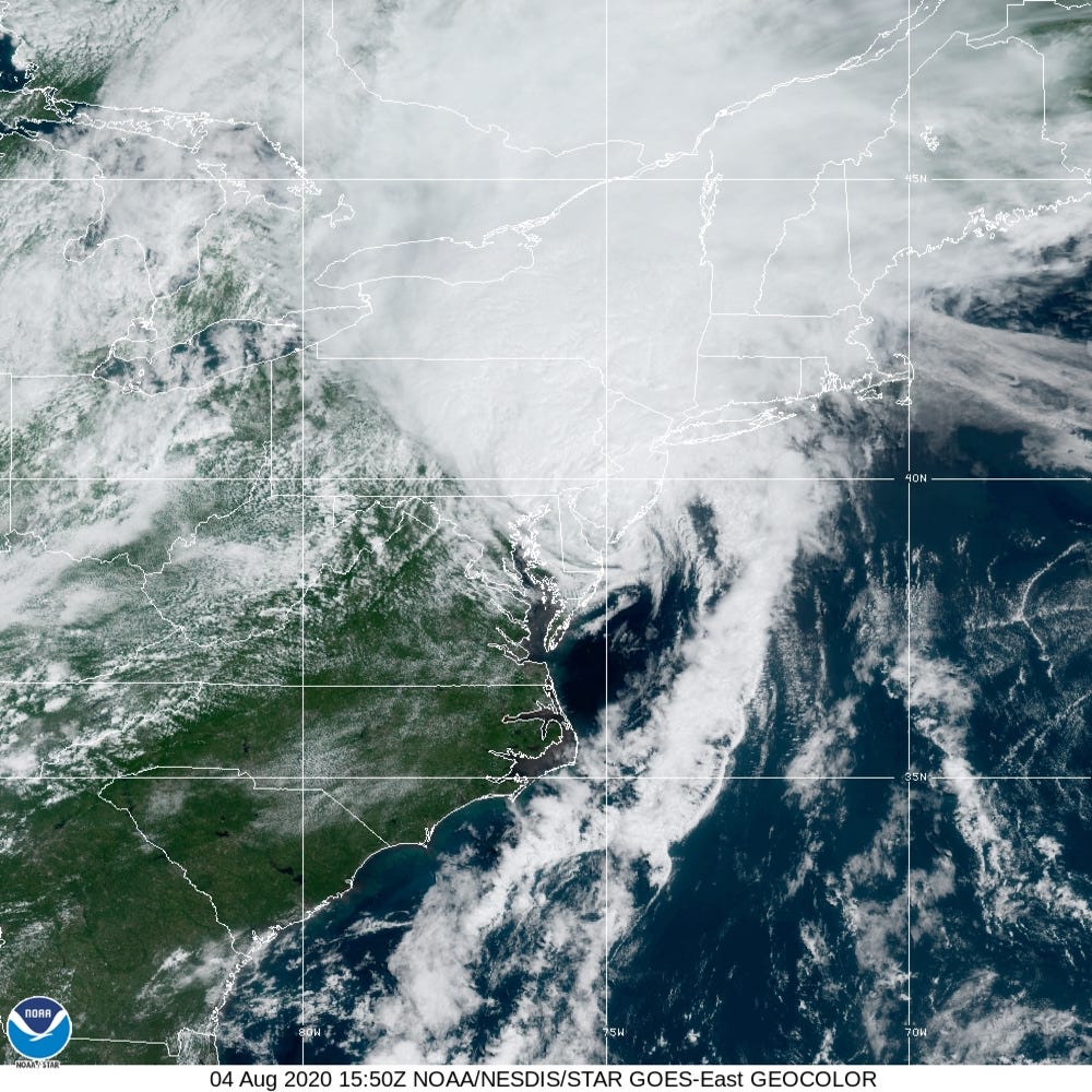
- Tropical Storm Isaias made landfall as a Category 1 hurricane Monday night near Ocean Isle Beach, North Carolina.
- Isaias led to more than 2 million power outages and caused Con-Edison’s second largest outage in company history.
- The storm killed at least five people.
- It was the earliest named storm starting with “I” in history.
- Visit Business Insider’s homepage for more stories.
After hitting Puerto Rico and several other Caribbean islands last week, Tropical Storm Isaias swept up the East Coast on Monday and Tuesday, spurring tornadoes and cutting power to millions.
The storm made landfall as a Category 1 hurricane in North Carolina on Monday night then moved north, but by Wednesday, Isaias had dissipated, according to the National Hurricane Center.
Felled trees crushed drivers in New York City and St. Mary’s County, Maryland. Tornadoes killed at least two people in a mobile home park in Bertie County, North Carolina. And at least one resident of Puerto Rico died last week, the New York Times reported.
The storm caused more than 2 million households to lose power by Tuesday evening, according to the tracking site PowerOutage.us. More than half of those were in New Jersey. Con Edison said the storm caused the second-biggest outage in company history, after Superstorm Sandy.
Isaias left a trail of damage

Isaias came ashore around 11 p.m. ET on Monday with maximum sustained winds of 85 mph. It was downgraded to a tropical storm early Tuesday. (The difference between a tropical storm and hurricane is a matter of wind speed: A tropical storm's winds blow at 39 to 73 mph, while a hurricane's are 74 mph or greater.)
In North Carolina, the hurricane triggered flooding and started fires at four homes, Ocean Isle Beach Mayor Debbie Smith told WECT-TV. Smith said flood waters reached 3 feet in some areas. Then as it moved north, the storm caused damage in Pennsylvania, New Jersey, and New York.
On Tuesday afternoon, some residents of Doylestown, Pennsylvania, reported that tornadoes hit a hospital and adjacent daycare center, causing cars to pile up in the hospital's parking lot and partially ripping off the center's roof.
Possible #tornado in Doylestown. This is the parking lot of Doylestown Hospital. @KYWNewsradio pic.twitter.com/hUeFwD4LuS
— Paul Kurtz (@kurtzpaul) August 4, 2020
In Belmont Hills, Pennsylvania, crews made several rescues after heavy rains caused roadways to flood, according to Philadelphia's ABC affiliate. Cars stalled in other parts of the state, including Philadelphia and Bryn Mawr.
I should have looked at the weather report before leaving my house this morning.
(photo of Belmont Ave. exit off of 76 in Philadelphia) pic.twitter.com/h32u1JJOHe— Bon Ku, MD, MPP (@BonKu) August 4, 2020
Isaias caused similar damage last week in the Dominican Republic and Puerto Rico, where it flooded roads, felled trees, and caused landslides. Hundreds of thousands of Puerto Rican residents experienced power outages, the Times reported.
More than 1 foot of rain fell in the Bahamas, then the hurricane's edge grazed Florida over the weekend.
As of Wednesday morning, the storm had moved towards southeastern Canada before finally dissipating.
The earliest named storm starting with 'I'
Isaias was the earliest named storm starting with "I" ever to form in a hurricane season. Because storms are named in alphabetical order, that means nine tropical storms have already formed - the first time that's happened before August 1 since the US began recording hurricane data in the 19th century.

The season's first hurricane, Hanna, made landfall in Texas on July 25, with wind speeds reaching 90 mph. Forecasts for the season overall predict a high activity, with up to six major storms (category 3 or higher).
Hurricanes are increasing in intensity due to climate change; they are expected to grow even stronger and more frequent as the planet continues to warm.
Because hurricanes use warm water as fuel, they have more to feed on as oceans warm. A 2013 study found that for each degree the planet warmed over the previous 40 years, the proportion of category 4 and 5 storms - the strongest hurricanes - increased by 25% to 30%.
Research from the National Oceanic and Atmospheric Administration, meanwhile, shows that each new decade over the last 40 years has brought an 8% increase in the chance that a storm turns into a major hurricane.
In addition to making hurricanes stronger, climate change is also making them slower and wetter: Over the past 70 years, the speed of hurricanes and tropical storms has slowed about 10% on average, according to a 2018 study. Slower hurricanes, like Dorian last year, linger longer over the same area, causing greater damage than a faster-moving storm would.
Aylin Woodward contributed reporting.
