- Harrowing satellite images show the scale of flooding caused by Hurricane Dorian as it tore through the Bahamas early this week.
- Storm surges, 30 inches of rain, and 185-mph winds battered Grand Bahama and the Abacos Islands from Sunday to Tuesday.
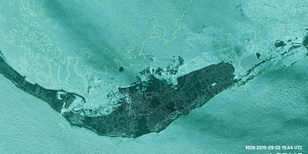
- Radar satellite images taken by one of the Finnish company Iceye’s microsatellites detail the extent of the flooding, which the company estimates covers 60% of Grand Bahama island.
- At least seven people died as a result of the storm in the Bahamas.
- Visit Insider’s homepage for more stories.
Stark images from a Finnish microsatellite lay bare destruction in the Bahamas as Hurricane Dorian ripped through the island chain on Monday.
Satellites from Iceye SAR Satellite Constellation captured extreme flooding on Grand Bahama and the Abacos Islands, the result of a 23-foot storm surge, 30 inches of rain, and 185-mph winds.
This animation gives a before-and-after look at the island of Grand Bahama, showing it largely submerged after Dorian.
Satellite imagery of a major storm and the devastation it leaves in its wake is always stunning.
But @iceyefi's X2 satellite is taking photos as #HurricaneDorian is happening, such as this view of flooding on the Grand Bahama island during the storm.https://t.co/9MRbLhEfwZ pic.twitter.com/OS4hdG5ipF
— Michael Sheetz (@thesheetztweetz) September 3, 2019
Iceye told the CNBC reporter Michael Sheetz that it estimated more than 60% of Grand Bahama was underwater as of midday on Tuesday.
The Iceye satellite used radar to capture the images, as it enabled the camera to penetrate the cloud cover.
Dorian made landfall in the Bahamas on Sunday, at the time a Category 5 storm. Maximum sustained winds were as high as 185 mph on Sunday, with gusts hitting 225 mph.

The storm moved incredibly slowly, causing the Bahamas to stay within Dorian's eyewall, the strongest part of the hurricane, for over a day, something few places have ever experienced.
By Tuesday, the winds had dropped, but only to 110 mph.
The hurricane has so far led to seven deaths in the Bahamas, according to officials.
The Red Cross estimates that as many as 13,000 homes may have been severely damaged or destroyed.