When I first got an iPhone three years ago, it only took me about 24 hours to make the switch from Apple Maps to Google Maps.
I had been using Android devices up until 2014, and the Apple Maps interface wasn’t intuitive to me. Google Maps seemed more reliable, and I was hesitant to trust Apple Maps after the countless bugs, glitches, and outright dangerous directions users were subjected to when the product rolled out in 2012.
From then on, my opinion of Apple Maps didn’t really change – until iOS 11 was unveiled this past June.
The new iPhone operating system, which arrived today, contains some major changes to Apple Maps. The updates make the app not only a solid mapping tool, but finally give Apple Maps capabilities that are equal to or even better than what Google Maps can do.
Nearly five years after launch, the newest update puts Apple Maps solidly on a par with Google – and it’s making me consider switching back for the first time ever.
Here are some of the major changes to Apple Maps with iOS 11.
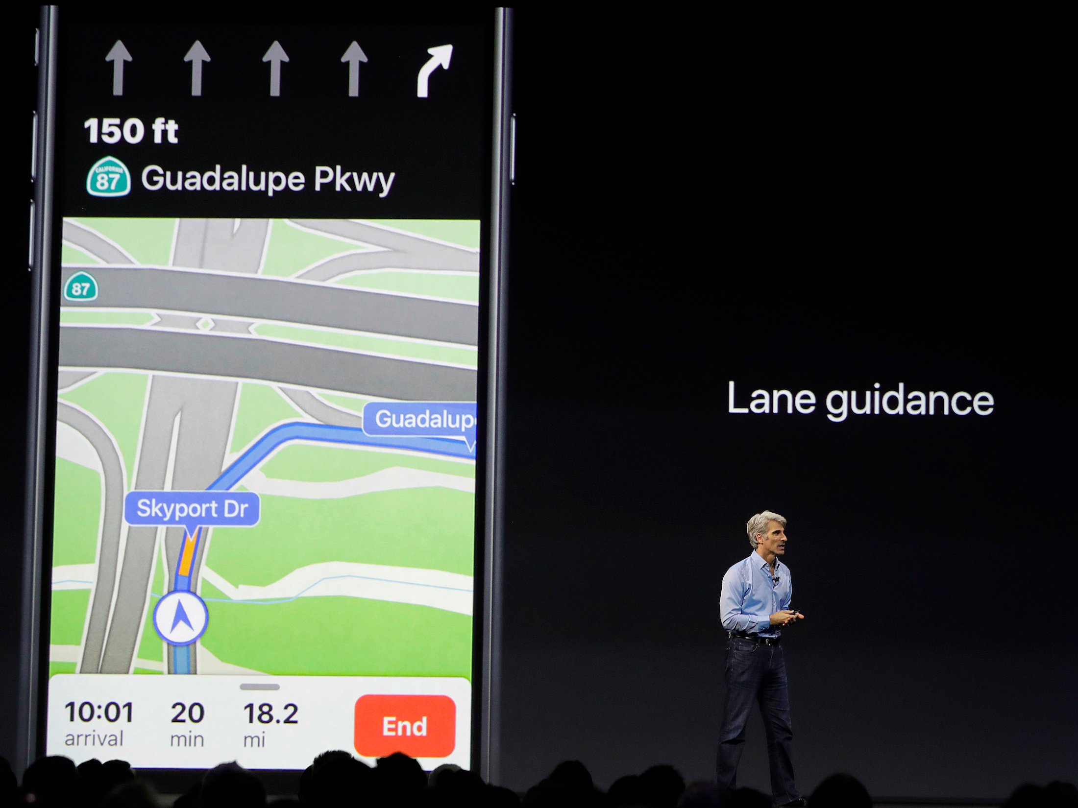
Lane guidance will tell you which lane to be driving in before making a turn or getting off a highway.

Google also offers a lane guidance feature, and most standalone GPS devices have this, too. But Apple's interface looks more modern than Google's, and it's nice to see the number of lane's displayed so prominently at the top. I can picture this being incredibly helpful when driving in a high-traffic area with several lanes.
Speed limits will show up in the corner of the screen at all times.

Unless you live in San Francisco or Rio de Janeiro, Brazil, you won't see speed limits in Google Maps. But Apple hasn't said if there are any limitations on where speed limits will pop up in its Maps app.
I drive across New York State a few times a year to visit family, which involves driving on both 70mph highways and tiny, 30mph towns. It's easy to miss a speed-limit sign or fall victim to a speed trap, so having the speed limit displayed at all times could save many drivers from future speeding tickets.
Light guidance works for routes you take often — you'll hear fewer prompts, see an overview of your trip, and get alternative routes while you're traveling.

Google only offers two forms of maps at the moment: turn-by-turn directions (which you can have on silent or spoken aloud) and a larger route overview. But Apple built a hybrid version, which could help make your commute a lot more enjoyable.
Apple is adding hundreds of indoor maps to iOS 11. Indoor maps for airports will show you where security is, help you find the nearest bathroom, and locate shops and restaurants in the terminal.

I recently flew through Atlanta, and finding the right terminal and gate required a long walk, a train trip, and more time than I had. But having indoor maps could change all that, or at least help you feel a bit less flustered while navigating unfamiliar airports.
While Google offers some indoor maps, the feature is limited right now. Apple's indoor maps feature won't be available in every airport and mall either, but it will support several hundred major hubs to start.
You'll also be able to see detailed floor plans for hundreds of malls. The app will show you what floor a store is on, search the mall directory, or narrow down your shopping destination by category.

iOS 11 for iPhone and iPad launched Tuesday. You can learn more about it here.

